CPO-0021Zagbayou Bamba
Buyo, Côte d’Ivoire · 1.90 ha · cocoa · 6.688000, -6.624209
Plot CPO-0021 (Zagbayou Bamba, Buyo, CI) covers 1.90 ha under cocoa. This land was already in agricultural use before the EUDR cut-off: less than the 0.5 ha FAO forest minimum was mapped as forest on 31 December 2020 (0.00 ha). Nothing was deforested to produce this commodity, which is the situation of the overwhelming majority of smallholder plots.
Imagery evidence
Rendered server-side from the same pixels the verdict was computed from. Deliberately not smoothed: blocky pixels are honest about what a 10-metre sensor can resolve. The white outline is the boundary the cooperative submitted.

Green: mapped as forest on 31 Dec 2020. Red: tree-cover loss after the cut-off. Amber: loss before the cut-off, which EUDR does not penalise. White outline: the declared plot.
JRC Global Forest Cover 2020 + Global Forest Change (Hansen/UMD)
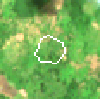
Cloud-free median of 1 Sentinel-2 acquisition from the period around 31 December 2020 — the state the law measures against.
Sentinel-2 L2A (surface reflectance) — median of 1 scene (S2A_29NQH_20210412_0_L2A)
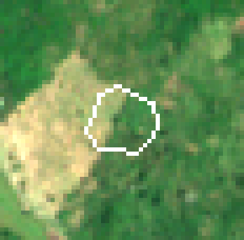
Cloud-free median of 1 recent Sentinel-2 acquisition over the same ground.
Sentinel-2 L2A (surface reflectance) — median of 1 scene (S2B_29NQH_20260312_0_L2A)
Three independent datasets
Each line is reported on its own terms. Where they disagree, the disagreement is shown rather than resolved by quietly preferring one source - because an auditor citing the other source is exactly the situation this has to survive.
Less than the 0.5 ha FAO minimum was mapped as forest on the cut-off date (0.00 ha). This land was already in agricultural use before EUDR applied.
JRC Global Forest Cover 2020 · V4 (2026 release) · European Commission — Joint Research Centre · 10 m · CC BY 4.0
No tree-cover loss was detected on baseline forest inside this plot after 31 December 2020.
Global Forest Change (Hansen/UMD) · GFC-2024-v1.12 · University of Maryland GLAD / Google · 30 m · CC BY 4.0
Vegetation indices have fallen since the cut-off (NDMI -0.118, NDVI -0.099), but this land was already in agricultural use in 2020. Article 2(3) defines deforestation as the conversion of forest to agricultural use, so change on land that was not forest is a crop or seasonal signal, not a breach. Recorded for the agronomy file, not for the verdict.
Sentinel-2 L2A (surface reflectance) · Collection 1, AWS Open Data · ESA Copernicus / Element 84 Earth Search · 10 m · Copernicus open licence
Every criterion assessed and recorded
Article 10(4) requires the operator to demonstrate how the information was checked against each criterion and how the degree of risk was determined. That means recording the criteria that came back clear, not only the ones that fired.
| Article | Criterion | Outcome |
|---|---|---|
| 10(2)(a) | Country risk classification Côte d'Ivoire: standard risk tier — simplified due diligence not available. | triggered |
| 10(2)(b) | Presence of forests in the country of production Côte d'Ivoire retains significant forest cover, so conversion risk is material and the geolocation analysis carries real weight. | triggered |
| 10(2)(c) | Presence of Indigenous Peoples No recognised Indigenous territories are recorded for Côte d'Ivoire in our country profile. | n/a |
| 10(2)(d) | Consultation with Indigenous Peoples Criterion (c) does not apply, so (d) does not arise. | n/a |
| 10(2)(e) | Claims by Indigenous Peoples over the land Criterion (c) does not apply, so (e) does not arise. | n/a |
| 10(2)(f) | Prevalence of deforestation in the country severe deforestation pressure recorded for Côte d'Ivoire. | triggered |
| 10(2)(g) | Source and reliability of the information 4 unresolved issue(s) on the submitted geolocation. | triggered |
| 10(2)(h) | Governance, corruption and enforcement concerns CPI 45/100 for Côte d'Ivoire does not indicate elevated falsification risk. | cleared |
| 10(2)(i) | Complexity of the supply chain Direct sourcing with full plot-level traceability. | cleared |
| 10(2)(j) | Risk of circumvention or mixing Volume reconciliation or duplicate-geometry checks flagged this supply. | triggered |
| 10(2)(k) | Conclusions of Commission expert groups No expert-group conclusion published in the Commission register currently bears on this commodity and origin in a way that changes the assessment. | cleared |
| 10(2)(l) | Substantiated concerns and non-compliance history No substantiated concerns under Article 31 and no recorded prior infringement in this chain. | cleared |
| 10(2)(m) | Any other information pointing to a risk No further adverse information identified; land tenure evidence is on file. | cleared |
| 10(2)(n) | Complementary certification information Covered by Fairtrade. Treated as complementary evidence only: Article 10(2)(n) admits it solely where it meets the Article 9 information requirements, and certification is never a substitute for geolocation. | cleared |
Only “negligible” (below 10) clears Article 10(1). Anything above it means Article 11 mitigation is owed before the product may be placed on the market.
This plot is credited with 4,560 kg from 1.90 ha, or 2,404 kg/ha. The highest recorded smallholder yield for cocoa is about 1,500 kg/ha and the regional norm is nearer 500. Volume in excess of a plot's biophysical capacity is the standard signature of product from undeclared land being booked against a compliant plot. This plot is credited with 4,560 kg from 1.90 ha, or 2,404 kg/ha. The highest recorded smallholder yield for cocoa is about 1,500 kg/ha and the regional norm is nearer 500. Volume in excess of a plot's biophysical capacity is the standard signature of product from undeclared land being booked against a compliant plot.
→ Reconcile delivery volumes against mapped area before the statement is filed.
Article 10(2)(g) turns on "the source, reliability, validity, and links to other available documentation" of the Article 9 information. Outstanding: Coordinates carry only 3 decimal digits; Declared harvest exceeds what this land can physically produce; Coordinates carry only 3 decimal digits; Declared harvest exceeds what this land can physically produce.
→ Resolve every blocker and error before the statement is submitted.
Côte d'Ivoire is experiencing severe rates of forest loss, much of it driven by the expansion of exactly this commodity. That raises the base rate of non-compliance for any plot in the country, independent of what this particular plot shows.
→ Maintain continuous monitoring rather than a one-time check.
Côte d'Ivoire is not on the low-risk Annex to Reg. 2025/1093, so it defaults to standard risk. The Article 13 simplified route is unavailable and the full Article 10 and 11 obligations apply. Competent authorities must check 3% of operators sourcing from here annually.
→ Complete Article 10 assessment and retain the evidence for five years.
- Verification id
- VER-B6EB4D9956B2
- Evidence hash
b6eb4d9956b266d8…- Plot geometry id
- PLT-42F9D2B3E18A042E
- Engine version
- 1.0.0
- Verified at
- 2026-09-15 10:00:00Z
- Capture method
- gps perimeter walk
Caveats and data-quality findings
Anything that weakens this verdict is recorded with it. A compliance tool that reports only its confident findings is a tool that will eventually be wrong in a way nobody saw coming.
This plot is credited with 4,560 kg from 1.90 ha, or 2,404 kg/ha. The highest recorded smallholder yield for cocoa is about 1,500 kg/ha and the regional norm is nearer 500. Volume in excess of a plot's biophysical capacity is the standard signature of product from undeclared land being booked against a compliant plot.
→ Reconcile the delivery records for this plot; the excess volume needs its own geolocation.
Written risk assessment
Assembled deterministically from the measurements rather than generated freely, so the same evidence always produces the same assessment.
Plot CPO-0021 (Zagbayou Bamba, Buyo, CI) covers 1.90 ha under cocoa. This land was already in agricultural use before the EUDR cut-off: less than the 0.5 ha FAO forest minimum was mapped as forest on 31 December 2020 (0.00 ha). Nothing was deforested to produce this commodity, which is the situation of the overwhelming majority of smallholder plots.
The finding rests on 3 independent evidence lines: JRC Global Forest Cover 2020 (V4 (2026 release)); Global Forest Change (Hansen/UMD) (GFC-2024-v1.12); Sentinel-2 L2A (surface reflectance) (Collection 1, AWS Open Data). Less than the 0.5 ha FAO minimum was mapped as forest on the cut-off date (0.00 ha). This land was already in agricultural use before EUDR applied. No tree-cover loss was detected on baseline forest inside this plot after 31 December 2020. Vegetation indices have fallen since the cut-off (NDMI -0.118, NDVI -0.099), but this land was already in agricultural use in 2020. Article 2(3) defines deforestation as the conversion of forest to agricultural use, so change on land that was not forest is a crop or seasonal signal, not a breach. Recorded for the agronomy file, not for the verdict.
The Article 10(2) assessment raised 4 findings, giving a composite risk score of 47 (standard). The most material are: Indicators of mixing with product of unknown origin [10(2)(j)]; 4 unresolved data-quality issues on the geolocation [10(2)(g)]; Severe national deforestation pressure [10(2)(f)].
The negligible-risk threshold in Article 10(1) is not met on the present evidence. Article 11 mitigation is owed before any product from this plot is placed on the market.