
EUDR applies to large and medium operators from 30 December 2026

Every bar of chocolate
starts with a map.

Protect forests without leaving smallholder farmers behind. Plotline turns messy field records and open satellite data into evidence a cocoa cooperative and its buyer can understand.

Find clearing after the 2020 cut-off. See the source images. Fix the paperwork. Build a traceable due diligence draft.

24 demo plots3 independent data sourcesNo sign-up needed

Fictional cooperative, real locations and saved satellite evidence. Live verification reads the public archives again. Screening supports human review; it does not certify legal compliance.

Verified evidence
CPO-0017 · Oupoyo, Côte d’Ivoire
Disqualified
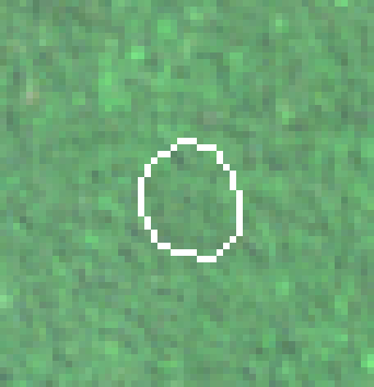
At the cut-off
2020-05-02
Cloud-free median of 1 Sentinel-2 acquisition from the period around 31 December 2020 — the state the law measures against.
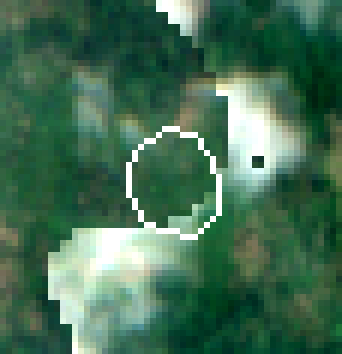
Latest saved scene
2026-08-04
Cloud-free median of 2 recent Sentinel-2 acquisitions over the same ground.
Green: mapped as forest on 31 Dec 2020. Red: tree-cover loss after the cut-off. Amber: loss before the cut-off, which EUDR does not penalise. White outline: the declared plot.

Green is forest on the cut-off date, per the Commission’s Global Forest Cover 2020 map. Red is tree cover lost after it. White is the plot the cooperative submitted. 2.09 hectares of forest inside this boundary were cleared in 2022, 2023, 2024.

See the full evidence bundle →
24
plots you can inspect

A fictional cocoa cooperative with real locations, saved imagery, and a mix of clear and flagged results.

3
complementary data sources

A forest baseline, annual loss history, and recent optical imagery. Each answers a different part of the question.

650
validation checks on the demo

Format, geometry, plausibility, duplicate boundaries and portfolio consistency are checked before a statement is built.

€0.0007
illustrative transfer cost per plot

Based on measured archive bytes priced at a commercial transfer rate. Excludes compute, hosting, model calls and human review. Live timings vary.

How it works

Three datasets, one question, an answer you can take to an auditor.

01

Read what the cooperative actually sent

Paste a field message, a transcribed notebook, or spreadsheet text. AI finds the fields. Code rejects coordinate strings absent from the source and performs the numerical conversions. Review the extracted records before use.

Try it on messy data →
02

Compare three satellite datasets

The Commission’s own JRC map says what was forest on the cut-off date. Hansen says what was cleared, and in which year. Sentinel-2 says what the land looks like now - and, crucially, how wet its canopy is, which is how you tell a rainforest from a three-year-old cocoa farm.

Read the method →
03

Show the disagreement, not just the verdict

Datasets conflict. A tool that hides that has no answer when an auditor cites the other one. Plotline reports each line separately, refuses to call plots it cannot resolve, and attaches the imagery a reviewer needs to judge for themselves.

Watch it run →
04

Produce the statement - or refuse to.

A due diligence statement is a legal attestation that no more than negligible risk was found. When the evidence does not support that sentence, the correct behaviour for software is to refuse to write it. Plotline builds the TRACES-shaped payload, the base64 GeoJSON, the Article 10 assessment against all fourteen criteria and a tamper-evident audit chain - and when a plot fails, it blocks the statement and tells the operator exactly which plot, which hectare and which article.

Data provenance

Open data, no API keys, no licence that a cooperative cannot afford

This is a product decision, not a convenience. A verification that depends on a commercial imagery licence can never be given away to the people who most need it, and a business model that cannot be given away to smallholders cannot solve this problem.

DatasetVersionProviderResolutionCoverageLicence
JRC Global Forest Cover 2020V4 (2026 release)European Commission — Joint Research Centre10 mGlobal, 60°S–80°N, state on 31 December 2020CC BY 4.0
Global Forest Change (Hansen/UMD)GFC-2025-v1.13University of Maryland GLAD / Google30 mGlobal, annual tree-cover loss 2001–2025CC BY 4.0
Sentinel-2 L2A (surface reflectance)sentinel-2-l2a (Earth Search, AWS Open Data)ESA Copernicus / Element 84 Earth Search10 mGlobal, 2015–present, ~5-day revisitCopernicus open licence
Earth Forward

How making proof cheap keeps a tree standing

Our intended impact is a shorter path from a farmer's records to a buyer's sourcing decision. This mechanism needs field validation, and the app makes its current capabilities visible.

Locate the land

Connect each delivery to a plot so a buyer can inspect its origin.

Traceability

Check for loss

Compare the forest baseline with dated loss records and recent imagery. Preserve source disagreements.

Satellite screening

Explain the next step

Show the cooperative what was found and what requires a new boundary, documents or human review.

Farmer inclusion

Make the decision reviewable

Block unresolved shipment drafts and package the evidence for an operator to inspect.

Due diligence support

7.00 ha
of post-cut-off loss flagged in the demo

Detected on 3 plots in this one cooperative and used to block the demonstration shipment. This shows a decision workflow, not a measured reduction in deforestation.

61.2 ha
of land with no detected post-cut-off loss

21 plots with saved screening evidence. The monitoring script can recheck them when new archive data is available.

€0.017
illustrative transfer cost across the demo

For all 24 plots, against live satellite archives. The whole argument rests on this number being small enough that nobody has to be excluded.

Plotline demonstrates screening and a review workflow. It does not plant trees, prove legal compliance, or measure avoided deforestation. Those outcomes need real deployments, field validation and human oversight.

The forest does not need another dashboard. It needs the proof to be cheap.

412 members. 24 plots in this workspace, every one verified against live satellite archives for a combined €0.017 - less than a cup of the coffee it protects.