CPO-0019Brou Diomandé
Méagui, Côte d’Ivoire · 2.25 ha · cocoa · 5.212625, -7.931911
Plot CPO-0019 (Brou Diomandé, Méagui, CI) covers 2.25 ha under cocoa. 2.25 ha of this plot was mapped as forest on 31 December 2020 and 2.25 ha of it has since been cleared (2021). Under Article 9(1)(d) that disqualifies the commodities from this plot from the EU market.
Imagery evidence
Rendered server-side from the same pixels the verdict was computed from. Deliberately not smoothed: blocky pixels are honest about what a 10-metre sensor can resolve. The white outline is the boundary the cooperative submitted.

Green: mapped as forest on 31 Dec 2020. Red: tree-cover loss after the cut-off. Amber: loss before the cut-off, which EUDR does not penalise. White outline: the declared plot.
JRC Global Forest Cover 2020 + Global Forest Change (Hansen/UMD)
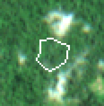
Cloud-free median of 1 Sentinel-2 acquisition from the period around 31 December 2020 — the state the law measures against.
Sentinel-2 L2A (surface reflectance) — median of 1 scene (S2B_29NPF_20200425_0_L2A)

Cloud-free median of 4 recent Sentinel-2 acquisitions over the same ground.
Sentinel-2 L2A (surface reflectance) — median of 4 scenes (S2A_29NPF_20251222_0_L2A, S2B_29NPF_20260111_0_L2A, S2C_29NPF_20260129_0_L2A, S2A_29NPF_20260312_1_L2A)
Three independent datasets
Each line is reported on its own terms. Where they disagree, the disagreement is shown rather than resolved by quietly preferring one source - because an auditor citing the other source is exactly the situation this has to survive.
2.25 ha of this plot (100%) was mapped as forest on the cut-off date. That does not make the plot non-compliant on its own — standing forest is not a breach — but it means any clearing after 31 December 2020 would be.
JRC Global Forest Cover 2020 · V4 (2026 release) · European Commission — Joint Research Centre · 10 m · CC BY 4.0
2.25 ha of land that was forest at the cut-off has since been cleared (2021).
Global Forest Change (Hansen/UMD) · GFC-2024-v1.12 · University of Maryland GLAD / Google · 30 m · CC BY 4.0
No cloud-free Sentinel-2 stack could be compared for this plot.
Sentinel-2 L2A (surface reflectance) · Collection 1, AWS Open Data · ESA Copernicus / Element 84 Earth Search · 10 m · Copernicus open licence
When the forest went
Hectares of land that was mapped as forest on the cut-off date and was cleared in each subsequent year.
Every criterion assessed and recorded
Article 10(4) requires the operator to demonstrate how the information was checked against each criterion and how the degree of risk was determined. That means recording the criteria that came back clear, not only the ones that fired.
| Article | Criterion | Outcome |
|---|---|---|
| 10(2)(a) | Country risk classification Côte d'Ivoire: standard risk tier — simplified due diligence not available. | triggered |
| 10(2)(b) | Presence of forests in the country of production Côte d'Ivoire retains significant forest cover, so conversion risk is material and the geolocation analysis carries real weight. | triggered |
| 10(2)(c) | Presence of Indigenous Peoples No recognised Indigenous territories are recorded for Côte d'Ivoire in our country profile. | n/a |
| 10(2)(d) | Consultation with Indigenous Peoples Criterion (c) does not apply, so (d) does not arise. | n/a |
| 10(2)(e) | Claims by Indigenous Peoples over the land Criterion (c) does not apply, so (e) does not arise. | n/a |
| 10(2)(f) | Prevalence of deforestation in the country severe deforestation pressure recorded for Côte d'Ivoire. | triggered |
| 10(2)(g) | Source and reliability of the information Geolocation passed all format, plausibility and integrity checks. Capture method: gps perimeter walk. | cleared |
| 10(2)(h) | Governance, corruption and enforcement concerns CPI 45/100 for Côte d'Ivoire does not indicate elevated falsification risk. | cleared |
| 10(2)(i) | Complexity of the supply chain Direct sourcing with full plot-level traceability. | cleared |
| 10(2)(j) | Risk of circumvention or mixing Declared volume is consistent with the mapped area and no duplicate geometries were found. | cleared |
| 10(2)(k) | Conclusions of Commission expert groups No expert-group conclusion published in the Commission register currently bears on this commodity and origin in a way that changes the assessment. | cleared |
| 10(2)(l) | Substantiated concerns and non-compliance history No substantiated concerns under Article 31 and no recorded prior infringement in this chain. | cleared |
| 10(2)(m) | Any other information pointing to a risk Land tenure evidence missing. | triggered |
| 10(2)(n) | Complementary certification information Covered by Fairtrade. Treated as complementary evidence only: Article 10(2)(n) admits it solely where it meets the Article 9 information requirements, and certification is never a substitute for geolocation. | cleared |
Only “negligible” (below 10) clears Article 10(1). Anything above it means Article 11 mitigation is owed before the product may be placed on the market.
Land inside this plot that the JRC mapped as forest on 31 December 2020 was cleared in 2021. Article 9(1)(d) states that any deforestation on a plot "shall automatically disqualify all relevant commodities and relevant products from those plots of land" from the EU market. This is not a risk to be mitigated; it is a disqualification.
→ Exclude this plot from the supply. Article 11 mitigation cannot cure an Article 3(a) failure.
Article 3(b) requires production in accordance with the law of the country of production, which starts with a right to use the land. Fewer than a third of smallholders surveyed by IISD in 2026 held clear land documentation, so an absence here is normal — but it is still an open risk the operator must address rather than ignore.
→ Collect the customary or statutory land record, or a cooperative attestation of cultivation rights.
Côte d'Ivoire is experiencing severe rates of forest loss, much of it driven by the expansion of exactly this commodity. That raises the base rate of non-compliance for any plot in the country, independent of what this particular plot shows.
→ Maintain continuous monitoring rather than a one-time check.
Côte d'Ivoire is not on the low-risk Annex to Reg. 2025/1093, so it defaults to standard risk. The Article 13 simplified route is unavailable and the full Article 10 and 11 obligations apply. Competent authorities must check 3% of operators sourcing from here annually.
→ Complete Article 10 assessment and retain the evidence for five years.
- Verification id
- VER-7EBC59FA8587
- Evidence hash
7ebc59fa85876985…- Plot geometry id
- PLT-28F6F56FD51B3A4D
- Engine version
- 1.0.0
- Verified at
- 2026-09-15 10:00:00Z
- Capture method
- gps perimeter walk
Caveats and data-quality findings
Anything that weakens this verdict is recorded with it. A compliance tool that reports only its confident findings is a tool that will eventually be wrong in a way nobody saw coming.
Written risk assessment
Assembled deterministically from the measurements rather than generated freely, so the same evidence always produces the same assessment.
Plot CPO-0019 (Brou Diomandé, Méagui, CI) covers 2.25 ha under cocoa. 2.25 ha of this plot was mapped as forest on 31 December 2020 and 2.25 ha of it has since been cleared (2021). Under Article 9(1)(d) that disqualifies the commodities from this plot from the EU market.
The finding rests on 3 independent evidence lines: JRC Global Forest Cover 2020 (V4 (2026 release)); Global Forest Change (Hansen/UMD) (GFC-2024-v1.12); Sentinel-2 L2A (surface reflectance) (Collection 1, AWS Open Data). 2.25 ha of this plot (100%) was mapped as forest on the cut-off date. That does not make the plot non-compliant on its own — standing forest is not a breach — but it means any clearing after 31 December 2020 would be. 2.25 ha of land that was forest at the cut-off has since been cleared (2021). No cloud-free Sentinel-2 stack could be compared for this plot.
The Article 10(2) assessment raised 4 findings, giving a composite risk score of 100 (severe). The most material are: 2.25 ha of deforestation detected on this plot [3(a) / 9(1)(d)]; No land tenure documentation on file [10(2)(m)]; Severe national deforestation pressure [10(2)(f)].
Article 11 mitigation cannot cure this. Article 9(1)(d) disqualifies the commodities from this plot automatically, so the plot must be excluded from the consignment and the volume attributed to it re-sourced.
Confidence qualifiers: Cloud limited the high-resolution comparison.
Methodological caveats recorded: Persistent cloud limited the high-resolution comparison; even after stacking multiple acquisitions, part of this plot had no clear satellite view.